Follow this link [GO]
Friday, April 5, 2013

Sunday, February 24, 2013
Vacancy for a GIS specialist
UNDP
Rs 50,000
6 months working experience
Contact: abjayasinghe@gmail.com
Wednesday, February 13, 2013
Python Scripting in ArcGIS
I found this small presentation in my search for a guide in ArcGIS Scripting. Hope it'll be useful to you too.
[Download]
[Download]
Tuesday, February 5, 2013
Wednesday, January 23, 2013
Vacancy for a Research Assistant
Post : Research Assistant
Research Topic : A
study on alternative Planning approaches to integrate climate change
adaptation into development plans of coastal urban areas, Sri Lanka (UGC funded Research Project)
Location : Faculty of Architecture, UoM
Duration :1 year (+1 year)
Qualifications : BSc (Hons) T&CP with special interset on Climate Change, Disaster Management, GIS
Salary : 25,000 - 30,000
Closing dates : 31st Jan 2013
(Please set the email subject as : RA_UGC_(your name), example: RA_UGC_AmilaJayasinghe)
Tuesday, January 22, 2013
Vacancy for a Environmental Planner
Job Tittle : Environmental Planner (at a EMS Unit):
Location : Leading Pvt Firm locate @ Colombo (for more details, please write to the given email address with your resume)
Location : Leading Pvt Firm locate @ Colombo (for more details, please write to the given email address with your resume)
Salary : SLR 80,000+ (BSc T&CP qualification) OR SLR 150,000+ (BSc T&CP + MSc in Env Planning qualification)
Please send short Resume to amilabjayasinghe@gmail.com (Subject : EP@EMS_Names e.g EP@EMS_Amila)
Number of positions: 1
Closing date: 25th Jan 2013
Sunday, January 13, 2013
Grabbing large size Satellite Images from Google Maps
If you have tried to save a satellite image from Google Earth, you might already experienced that The Google Earth allows us only to save small size satellite images, usually the same size of the display window of Google Earth. If we need a larger size image, we have to download a large number of images and merge them together. If you have already tried it, you might find that is a time consuming job.
But, there is a way to grab large size images from Google Earth free version (I am sure Google Earth Plus allows us to download large size images).
There can be many other methods. Here I am sharing the method I use, which have been very useful to me in many times.
1. Install Mozilla Firefox, if you don't have it in your computer (Chrome might also do the job, but I have never tried it).
2. Install the Add-On

Again, there are many, but I use this. Feel free to try others too.
3. Goto Google Maps and find the area you want to grab in.
4. Click on "Link" button.


5. Click on "Customized and preview embedded map" in the popped up box.

6. In the new window, input the desired size of the map, you want to grab.

7. Copy the HTML code provides at the bottom of the window.

8. Open the Text Editor (Note Pad in MS Windows) and paste the code.
9. "Save As" a HTML file.
10. Open the saved HTML file in Mozilla FireFox.
11. Make sure the required area is covered in the map or satellite image.
12. Goto Tools menu > ScreenGrab!> Save > Complete Page/Frame
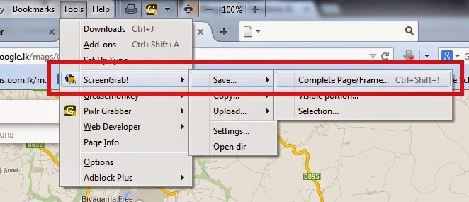
13. It may take few minutes to save the image into your HDD, depending on your computer performances and the internet connections speed.
14. Now, take coordinates of two reference points from Google Earth and Geo-reference your satellite image.
If you want to geo-reference it in local or any other coordinate system, there are plenty of transforming tools in the internet. The one I often use is "FRANSON CoordTrans".
Enjoy!!!
NOTE: I believe this process is NOT illegal. If it is, please don't do it.
But, there is a way to grab large size images from Google Earth free version (I am sure Google Earth Plus allows us to download large size images).
There can be many other methods. Here I am sharing the method I use, which have been very useful to me in many times.
1. Install Mozilla Firefox, if you don't have it in your computer (Chrome might also do the job, but I have never tried it).
2. Install the Add-On
Again, there are many, but I use this. Feel free to try others too.
3. Goto Google Maps and find the area you want to grab in.
4. Click on "Link" button.
5. Click on "Customized and preview embedded map" in the popped up box.
6. In the new window, input the desired size of the map, you want to grab.
7. Copy the HTML code provides at the bottom of the window.
8. Open the Text Editor (Note Pad in MS Windows) and paste the code.
9. "Save As" a HTML file.
10. Open the saved HTML file in Mozilla FireFox.
11. Make sure the required area is covered in the map or satellite image.
12. Goto Tools menu > ScreenGrab!> Save > Complete Page/Frame
13. It may take few minutes to save the image into your HDD, depending on your computer performances and the internet connections speed.
14. Now, take coordinates of two reference points from Google Earth and Geo-reference your satellite image.
If you want to geo-reference it in local or any other coordinate system, there are plenty of transforming tools in the internet. The one I often use is "FRANSON CoordTrans".
Enjoy!!!
NOTE: I believe this process is NOT illegal. If it is, please don't do it.
Subscribe to:
Posts (Atom)