If you have tried to save a satellite image from Google Earth, you might already experienced that The Google Earth allows us only to save small size satellite images, usually the same size of the display window of Google Earth. If we need a larger size image, we have to download a large number of images and merge them together. If you have already tried it, you might find that is a time consuming job.
But, there is a way to grab large size images from Google Earth free version (I am sure Google Earth Plus allows us to download large size images).
There can be many other methods. Here I am sharing the method I use, which have been very useful to me in many times.
1. Install Mozilla Firefox, if you don't have it in your computer (Chrome might also do the job, but I have never tried it).
2. Install the Add-On

Again, there are many, but I use this. Feel free to try others too.
3. Goto Google Maps and find the area you want to grab in.
4. Click on "Link" button.


5. Click on "Customized and preview embedded map" in the popped up box.

6. In the new window, input the desired size of the map, you want to grab.

7. Copy the HTML code provides at the bottom of the window.

8. Open the Text Editor (Note Pad in MS Windows) and paste the code.
9. "Save As" a HTML file.
10. Open the saved HTML file in Mozilla FireFox.
11. Make sure the required area is covered in the map or satellite image.
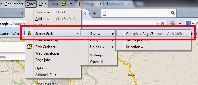
12. Goto Tools menu > ScreenGrab!> Save > Complete Page/Frame
13. It may take few minutes to save the image into your HDD, depending on your computer performances and the internet connections speed.
14. Now, take coordinates of two reference points from Google Earth and Geo-reference your satellite image.
If you want to geo-reference it in local or any other coordinate system, there are plenty of transforming tools in the internet. The one I often use is "FRANSON CoordTrans".
Enjoy!!!
NOTE: I believe this process is NOT illegal. If it is, please don't do it.
But, there is a way to grab large size images from Google Earth free version (I am sure Google Earth Plus allows us to download large size images).
There can be many other methods. Here I am sharing the method I use, which have been very useful to me in many times.
1. Install Mozilla Firefox, if you don't have it in your computer (Chrome might also do the job, but I have never tried it).
2. Install the Add-On
Again, there are many, but I use this. Feel free to try others too.
3. Goto Google Maps and find the area you want to grab in.
4. Click on "Link" button.
5. Click on "Customized and preview embedded map" in the popped up box.
6. In the new window, input the desired size of the map, you want to grab.
7. Copy the HTML code provides at the bottom of the window.
8. Open the Text Editor (Note Pad in MS Windows) and paste the code.
9. "Save As" a HTML file.
10. Open the saved HTML file in Mozilla FireFox.
11. Make sure the required area is covered in the map or satellite image.
12. Goto Tools menu > ScreenGrab!> Save > Complete Page/Frame
13. It may take few minutes to save the image into your HDD, depending on your computer performances and the internet connections speed.
14. Now, take coordinates of two reference points from Google Earth and Geo-reference your satellite image.
If you want to geo-reference it in local or any other coordinate system, there are plenty of transforming tools in the internet. The one I often use is "FRANSON CoordTrans".
Enjoy!!!
NOTE: I believe this process is NOT illegal. If it is, please don't do it.
This seems like a great solution, but when I try to open it with Firefox (23.0.1 on a Mac), all I see is the code, no map.
ReplyDeleteCan you email me the html you made?
DeleteSame here, on a mac.
DeleteTry this out.
DeleteMuch better way to extract satellite images with automatic georeferencing.
https://youtu.be/lBWF7cdvDrE
that happens when the html codes are incomplete. you might not have copied all the codes to the text file.
ReplyDeleteTry this out.
DeleteMuch better way to extract satellite images with automatic georeferencing.
https://youtu.be/lBWF7cdvDrE
It (still) works. grabbed my city map at 10.000 by 6600 px.
ReplyDeleteTry this out.
DeleteMuch better way to extract satellite images with automatic georeferencing.
https://youtu.be/lBWF7cdvDrE
I second that it _still_ works: 8000 by 14000 pixel satellite imagery. Thanks for the tip!
ReplyDeleteHint: In the iframe's "src" (url) "ll" is the lat/long coordinate in decimal form, and "z" is the zoom level, i.e. 0 (world) to 21+ (street/trees/houses).
Try this out.
DeleteMuch better way to extract satellite images with automatic georeferencing.
https://youtu.be/lBWF7cdvDrE
Dear All...
ReplyDeleteI just updated the guide with the latest version of the GoogleMaps website.
Thank you for your kind feedback.
Cheers!
I can't get anything to work. Maybe some sort of trouble with the iframe tag??? I can't even paste the code in this comment!
ReplyDeletecould you please send me the code you are trying to work with? toaruna@gmail.com
DeleteTry this out.
DeleteMuch better way to extract satellite images with automatic georeferencing.
https://youtu.be/lBWF7cdvDrE
Amigo, fiz o seu procedimento. Porém, sempre fica uma grande borda em torno do mapa. Existe algum modo de retirara? Eu quero uma imagem de 50000x50000 para imprimir, com o nome de todas as ruas. Você pode me ajudar?
ReplyDeleteFriend, did your procedure. However, there is always a wide border around the map. Is there any way to retired? I want a picture of 50000x50000 to print with the name of every street. Can you help me?
Hi,
DeleteIf you are still looking for a solution, reduce the size of the frame. 5000x5000 works fine with my internet connection.
Try this out.
DeleteMuch better way to extract satellite images with automatic georeferencing.
https://youtu.be/lBWF7cdvDrE
Try this out.
ReplyDeleteMuch better way to extract satellite images with automatic georeferencing.
https://youtu.be/lBWF7cdvDrE